Bill, I did a google search for "Oregon maps". The first one was easy,except that it was multiple steps. I clicked on "reply" at the bottom of the thread page, then "go advanced", then in that window "manage attachments". In that window I clicked " add files" in the upper right hand corner. The next window is small and in the top blue bar is "website", click on that. That brings up an even smaller window with a box titled "enter URL of the file". At that point I already had my chosen map in another browser. I "copied" the address of the map at the top of the page and "pasted" it into the URL box.Then I clicked on "upload" which transfered it to the new post.
I used the same process for the second and third maps, except that the map was way too big and had to be shrunk to fit. The shrinking process took the original 2094X1338 size map down to 800X600 size to fit the "manage attachments" requirements. The shrinking process, and adding the boxes and text, is where my daughter lost me, big time.
I didn't use the TCC mod on that trip, didn't think of it the only time it might have helped. The highway is good enough that I was able to keep speed up above 47 except for the last pull going up to the summit. That's when I could have used it, but forgot. Coming down the east side of the summit is about five miles of downhill, but good road, which drops about 2000 ft. There, at the upper end, I just dropped down to third gear to keep from picking up too much speed. Then down towards the bottom where there aren't anymore corners I just went back to fourth gear.
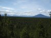
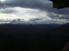
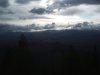
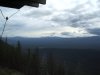
I'm going to post some pics of the area as promised last night. It just got too late for me and my slow hunt and peck typing after I had organized the pics.
Don